
Topographical surveying is a method of land measurement used to understand the contour and features of an area, in order to reduce risks related to terrain-related construction, planning and other activities.
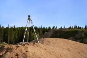
Surveyors use tools such as theodolites, plane tables, GPS units and maps for conducting topographical surveys. When planning these investigations, weather conditions must also be taken into consideration to produce accurate results.
Geodetic Measurements
Surveyors use geodetic measurements to establish horizontal positions relative to previously surveyed points known as control points, often indicated with metal benchmarks fixed into the ground in the field. The National Geodetic Survey maintains a system of control points with different orders of accuracy depending on what level of stability is necessary to conduct accurate surveys.
They use GPS receivers and total stations that combine electronic distance measurement with theodolite functions to precisely track displacements between points, and then record this data into their three-dimensional monitoring database.
The topographic surveys they do are often undertaken before development or construction begins, in order to gain a fuller picture of a piece of land. They depict natural or structural features on a property, such as boundary lines, trails, roads, and bodies of water. A typical map usually contains contour lines – brown lines which indicate elevation changes within terrain – in addition to symbols representing red boundaries or black survey lines.
Triangulation
Engineers conducting topographic surveys can utilize contour lines and other information such as weather data to accurately map land and pinpoint elevation changes, while also using this data to locate natural and man-made features like streams, large boulders, or wooded areas as well as any underground utilities.
Triangulation is the foundational surveying technique, in which triangles are created between points whose locations are known. From these data can be extracted the length and angles of one line (called a baseline), as well as their respective baselines and base angles, with pinpoint accuracy.
Electronic distance measurement (EDM) and satellite-based systems have largely replaced traditional methods of triangulation for topographic surveys, yet this method remains an invaluable asset when needed. You can click here to learn more, in-depth about the process. Different levels of accuracy are needed depending on its use – primary triangulation can be employed for cadastral mapping while secondary and tertiary triangulation systems tend to be employed during engineering projects.
Contour Lines
Contour lines are imaginary lines connecting points of equal elevation above a given level, such as mean sea level. No two contour lines intersect each other but may come close together or spread apart depending on their spacing; this information can give us clues as to the slope of terrain; for instance, closer contour lines indicate steep terrain while further apart indicates a gentler terrain slope.
Many topographic maps include a contour interval indicator in their legends to allow users to calculate elevation by picking two adjacent contour lines and subtracting their associated numbers from each other. You can do this easily.
The shape and direction of contour lines can provide insight into landforms. For instance, when they converge into one point to indicate a cliff; otherwise, they will form V or U shapes that point downstream or upstream from streams, valleys, canyons, rivers, or lakes respectively; finally, ridgelines will typically extend in all directions rather than come to a single point.
Topographic Maps
Topographic surveys produce maps that depict the surface features of an area. These maps are utilized by surveyors, military personnel, architects, and other professionals that need an understanding of the lay of the land (https://www.fao.org/fishery/topography); hikers and backpackers find them particularly useful since it allows for an aerial perspective of terrain that would otherwise be difficult to observe from ground level.
Topographic maps typically come in color-coded versions to highlight individual features – water is typically printed blue while roads and structures appear black or brown on most maps with margins typically showing distance scales so one inch on their maps equals a certain number of feet on land – ideal for hikers and backpackers!
Topographic surveys can be performed using various types of equipment, but robotic total station instruments are the most frequently employed. Equipped with a feature code list that enables surveyors to string survey points together into an outline of a building for example, these instruments also measure slope which can prove invaluable when planning construction projects and helping keep them within budget and schedule.